|
|
Open Water Swimming Victoria
Casey Seals Masters Swimming Club
|
|

Victorian Bay, Beach and Ocean conditions

|
Current Port Phillip Bay dataCurrent details about Port Phillip Bay, including:
|

|
Port Phillip Bay water temperatureGraph of Port Phillip Bay (north, mid & south) and Bass Strait ocean water temperatures. |

|
Bass Strait sea surface temp mapA map of 6-day water temperatures in Bass Strait, including Port Phillip and Westernport Bays. |

|
Westernport Bay water temperatureGraph of Westernport Bay (north, mid & south) and Bass Strait ocean water temperatures. |
|
|
Wave buoy at Point NepeanThe Port of Melbourne site has a link to view the current swell height and water temperature in Bass Strait off Portsea. |

|
Bass Strait Wave BuoysThis is a project to set up a network of wave buoys along the Victorian coast to allow models to be built of how climate change will affect Victoria's future wave climate. |
|
|
SwellnetSwellnet provides very accurate swell & surf forecasts and also has live webcams at various beaches around Australia. |
|
Trigger Brothers surfshopThe Trigger Brothers surfshop. This has live webcams at Point Leo, Sorrento back beach, Lorne, Torquay, Flinders & Gunnamatta so you can see what it's like out there. |
|
|
Victorian EPA beach reportCheck how clean the beach is before going there. |
|
Clean Ocean FoundationStop dumping waste and sewerage in our oceans. Also has some useful info and links. |
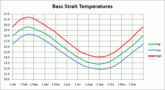
Bass Strait water temperatures
This graph shows the water temperature through the year in Bass Strait. This was based on figures from 2000 to 2010 from Andrew Watkins' excellent site at www.baywx.com. The low and high lines show the coldest and warmest temperatures over the sample period.
Andrew has a more detailed version on his BAYWX website.
Other useful Open Water Swimming pages
If you didn't find what you were looking for on this page, or would like to browse for more information about open water swimming or beach & water conditions, try these pages:
- Back to OWS home page
- Listing of all Victorian Open Water Swim events
- Map of the locations of all Victorian Open Water Swim events
- Victorian Open Water Swim events calendar
- Open Water Swim training squads, groups and events
© Copyright Casey Seals Masters Swimming Club Inc. (ABN 24 548 628 695).
No unsolicited commercial electronic messages. The display of any contact details on this website is not an invitation for such messages.
Please note the Copyright Notice and Disclaimer relating to the use of the information on this site. Users of web pages on this site are deemed to have read and accepted the conditions described therein.
![]()
We acknowledge the Traditional Custodians of country throughout Australia and acknowledge that they never ceded sovereignty. We recognise their continuing connection to the land and waters, and pay respect to Elders past and present as well as any First Nations people reading this website.